
Ohio’s transportation network serves as a critical bridge between the Northeast, the Midwest, and the American South. Positioned within a day’s drive of roughly 60% of the U.S. population, the Buckeye State features highly traveled freight corridors that experience immense commercial transit.
From the tightly packed metro loops of Cleveland and Cincinnati to the sprawling freeway systems traversing Columbus, Ohio’s roads see a relentless mix of local commuters and heavy interstate shipping.
While the state’s well-structured highway network keeps the regional economy moving, severe Midwestern winter storms, persistent construction zones, and high speed limits combine to create significantly hazardous driving conditions.
Staying highly alert during sudden lake-effect whiteouts or rush-hour gridlock is essential. Navigating these unpredictable elements safely makes keeping a reliable roadside assistance program active a crucial layer of security for any Ohio driver.
According to data compiled by the Ohio State Highway Patrol and the National Highway Traffic Safety Administration (NHTSA), several specific corridors stand out for having a high density of fatal accidents. Here is an in-depth look at Ohio’s most dangerous roads.
1. Interstate 71 (I-71): The Deadliest Metro Stretch
Running diagonally from Cincinnati through Columbus up to Cleveland, Interstate 71 is a core transit artery in Ohio.
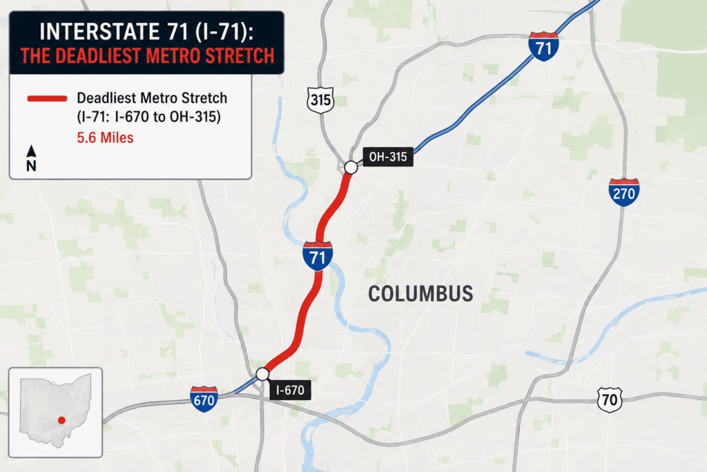
According to multi-year fatal crash tracking, a specific 5-mile segment of I-71 in Columbus holds the title for the deadliest individual stretch of road in the state.
- The Columbus Core Hotspot: The stretch of I-71 between Exit 110B (Hudson Street) and Exit 116 (Morse Road) in Franklin County experiences an exceptionally high fatal accident density.
- The Friction Points: This urban corridor suffers from compressed lane configurations, heavy daily commuting volumes, and frequent lane-weaving as drivers transition through closely spaced metropolitan exits.
2. Interstate 75 (I-75): The Industrial Shipping Trap
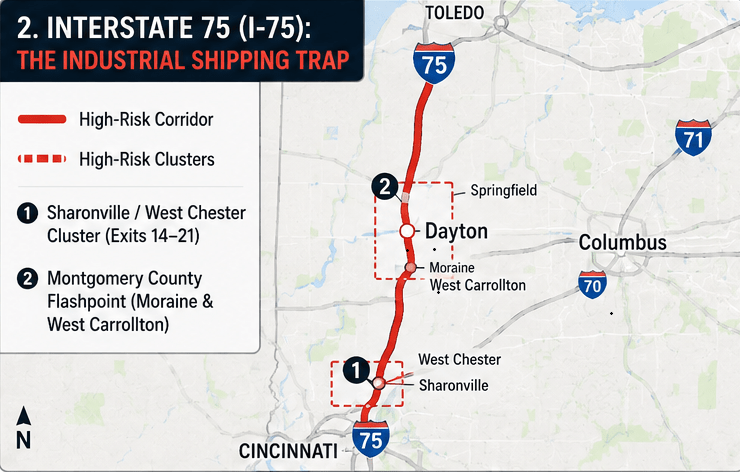
Interstate 75 cuts vertically through western and western-central Ohio, linking Toledo, Dayton, and Cincinnati. Because it serves as a premier overland shipping vein connecting the Great Lakes to the Gulf Coast, it is heavily saturated with commercial semi-trucks.
- The Sharonville / West Chester Cluster: The segment of I-75 running through Hamilton and Butler counties (specifically around Exits 14 to 21) is a major accident hotspot. High speeds combined with dense commuter traffic entering and exiting northern Cincinnati suburbs create severe speed differentials.
- The Montgomery County Flashpoint: Further north near Dayton (around Moraine and West Carrollton), I-75 experiences highly volatile stop-and-go patterns caused by industrial merges and persistent infrastructure widening projects.
3. U.S. Route 40 (Broad Street, Columbus): The High-Risk Surface Arterial
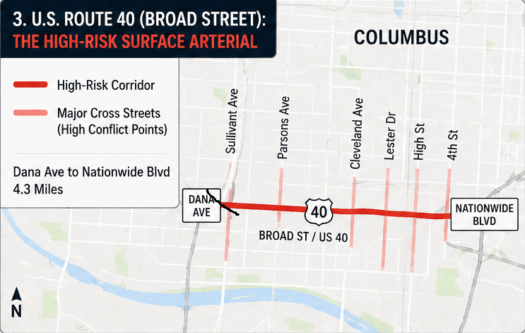
While major interstates frequently dominate highway safety reports, U.S. Route 40, specifically the stretch known locally as Broad Street in Columbus, consistently ranks near the absolute top of the state’s deadliest roads.
- The Dana Avenue to Nationwide Boulevard Stretch: This 4.3-mile corridor operates as a high-volume municipal thoroughfare rather than a controlled expressway.
- The Conflict Variables: Vehicles traveling at high speeds must constantly interact with local intersections, retail driveways, sudden turning traffic, and a high density of local pedestrians. The combination results in a disproportionate number of severe side-impact (T-bone) collisions.
Statistical Overview: Ohio’s Highest-Risk Driving Corridors
Data from the Fatal Accident Reporting System (FARS) indicates that while the state’s urban cores log the most frequent collisions, behavioral factors like impaired driving play a massive role statewide.
| Highway Corridor | Highest-Risk Regional Focus | Primary Contributing Factors |
| I-71 | Franklin County (Columbus proper) | Extreme urban traffic density, aggressive lane changes |
| I-75 | Hamilton (Cincinnati) & Montgomery (Dayton) | Heavy commercial freight volume, tailgating, tight merges |
| U.S. 40 (Broad St) | Downtown & West Columbus | Pedestrian conflicts, intersection collisions, sudden braking |
| I-480 (Outerbelt S) | Cuyahoga County (Cleveland suburbs) | Severe winter lake-effect ice, rapid suburban loop merging |
| I-90 (Lakeland Fwy) | Cleveland, Euclid, & Bratenahl | High-speed multi-lane friction, blinding winter snow |
4. Interstate 480 (The Outerbelt South Freeway): Cleveland’s Winter Hazard
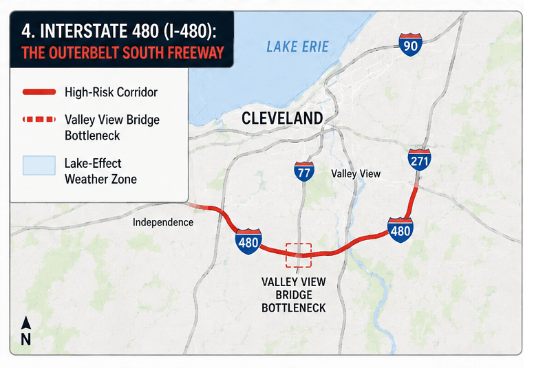
Skirting the southern edge of Cleveland through Cuyahoga County, Interstate 480 is a vital suburban auxiliary loop that experiences intense traffic volume.
- The Valley View Bridge Bottleneck: The sections passing through Independence and Valley View are notorious for high-speed commuter friction.
- Lake-Effect Volatility: Because of its northern geography, I-480 is highly susceptible to rapid weather shifts off Lake Erie. Sudden winter black ice conditions and blinding whiteouts regularly trigger massive chain-reaction pileups on the freeway’s elevated structures and bridges.
5. Interstate 90 (The Lakeland Freeway / Northeast Corridor)
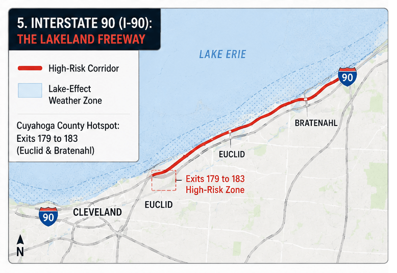
Interstate 90 spans the entire northern edge of Ohio, running through Cleveland before tracing the shoreline of Lake Erie toward the Pennsylvania border.
- The Cuyahoga County Hotspot: The stretch between Exit 179 and Exit 183 (running through Euclid and Bratenahl) logs high fatal accident rates. Drivers on this high-speed expressway frequently push well past the legal limit during off-peak hours.
- The Weather Factor: Much like I-480, I-90 bears the full brunt of northern winter weather. Drifting snow, freezing asphalt temperatures, and sudden drops in visibility make the northeastern segments of I-90 highly deceptive and dangerous for unprepared drivers.
The Behavioral Reality: State accident data reveals that human behavior remains the single largest variable on these dangerous corridors. Operating a vehicle while impaired (OVI) factors into over 49% of all fatal crashes in Ohio, while excessive speeding contributes to nearly 30% of the state’s highway fatalities.
Stay Prepared for the Unexpected on Ohio’s Roads
Driving through Ohio’s busiest highways can present unexpected challenges, from heavy freight traffic on I-75 to winter hazards on I-90 and congested urban corridors like U.S. Route 40 and I-480.
Staying alert, following traffic laws, and adapting to changing road conditions can significantly reduce your risk of being involved in a collision. If you experience a breakdown, a flat tire, or need roadside assistance after an incident, professional towing, tire repair, or mobile mechanic services can help get you back on the road safely.
For fast, dependable roadside support anywhere you need it, contact DriveSafe Solutions today at +1 (866) 890-7355 and let experienced professionals help you continue your journey with confidence.